


.png)


After years of research and development, Peterborough City Council is to approve its on-street parking permit pilot project, with additional direction for City of Peterborough staff to consult council with their initial findings on parking capacity in select zones.
This comes three years after a comprehensive review of the City’s parking standards was presented to council, providing the groundwork for an extensive overhaul of the parking system within Peterborough. Among the recommendations was the development of an on-street residential parking permit system based on the needs of any given area within city limits.
According to the initial October 2023 report, this expansion of the parking system would support further development and intensification within Peterborough, as on-street permit parking provides a cheaper alternative to public parking structures and surface lots and would readily utilize pre-existing infrastructure. Residential permit parking will also be a sorely needed revenue source for the City in light of its growing infrastructure needs.
“This will allow local residents to park on select streets to address spillover impacts of residential intensification, in proximity of residential areas where dedicated public parking lots are not available,” the October 2023 report says.
The pilot program was identified as a part of the City’s Housing Accelerator Fund (HAF) application, and was also flagged as a crucial aspect of updating parking by-laws to streamline development applications as a part funded by the province of Ontario through its Streamline Development Approvals Fund grant program.
Now, the City and its engineering consultant Cima+ have identified three study areas for the pilot program, encompassing the following areas depicted in this map. These areas best reflect operating conditions in various residential and mixed-use neighbourhoods within the city’s limits, and are also within three of the City’s seven strategic growth corridors.
The pilot study will run for 12 months from March 31, 2026 to March 26, 2027. Residents within the study areas can purchase a maximum of three permits per address from March 31 onward at the posted rates:
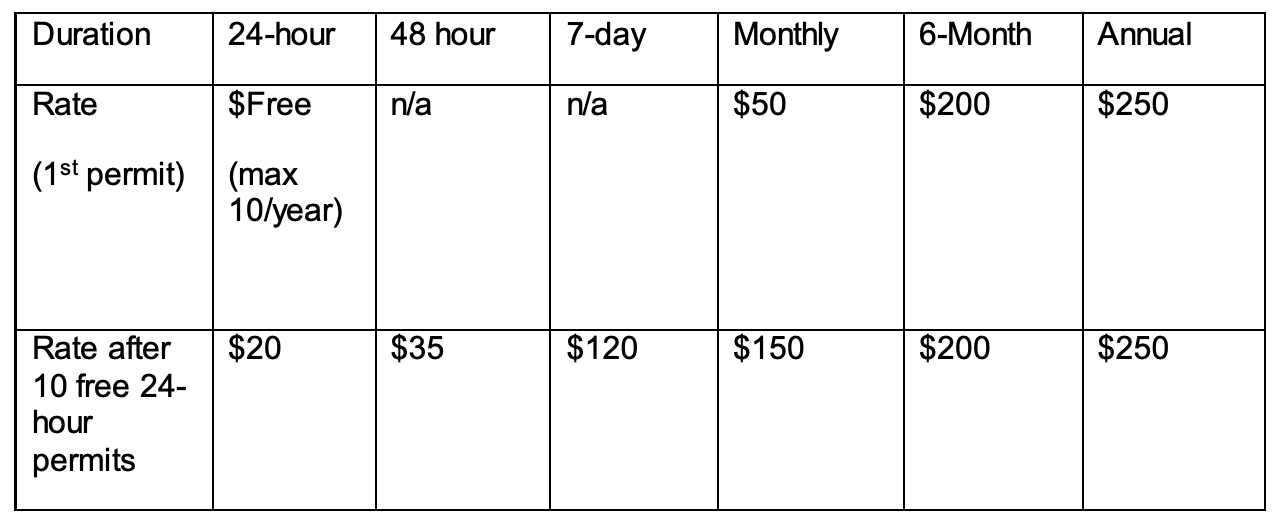
There will be a maximum number of permits available for each pilot area (75% of total legal parking spots) but the cap may be lifted during the pilot, contingent on feedback garnered from residents and data collected within these areas. Requirements for obtaining on-street parking permits include submitting proof of residency, proof of vehicle ownership, and includes a check on unpaid parking infractions.
At the March 2nd general committee meeting of Peterborough City Council, some councillors said they felt left out of the pilot study, including Town Ward’s Alex Bierk. Bierk first moved to amend one specific pilot area within Town Ward to extend north, including an additional zone of study from Weller Street to McDonnel Street, inclusive of Murray Street, Hopkins Avenue, and other residential streets within the area.
Bierk cited the conditions of these downtown streets being beneficial to widening the purview of the pilot study. He cited consistent spillover from high-density apartment buildings, the presence of bike lanes, and the lack of on-street parking near multi-unit residential buildings
“The pilot itself recognizes that some streets have limited capacity and allows zone adjustments during implementation to reflect real world conditions and resident feedback,” Bierk said. “I think that extending zone one north to McDonnel simply aligns with the pilot boundary… with the city's own criteria, and ensures residents in these constrained streets are included.”
Acting Director of Asset Management and Capital Planning Ian Boland felt differently about the further inclusion of that downtown strip, citing how Bierk’s addition could delay the pilot program, as the program is funded by the Housing Acclerator Fund and further delay beyond the end of March deadline could risk a loss of that funding.
“It's not exactly as simple for identifying and expanding some of these areas as just, you know, drawing a line on a map,” Boland told council. “[O]ur consultant does put in quite a bit of work ahead of time to determine how many potential parking spaces there are, what limitations are there? How many signs might be required to implement this? So it would take a little bit of time, you know, if we were to expand any areas.”
Bierk, however, wasn’t convinced that his request would delay the program’s implementation.
“I'm not talking about a broad area here. It's a couple of blocks,” Bierk added. “I believe that we have the mapping technology to understand very quickly and easily how many residential units there are and what the makeup of those are.
“Being naive, I could do it in 45 minutes. I could drive [to] the zone that I'm asking to extend it to and just take a stock with the clipboard and pencil of the existing road signs … there. I understand that this is a naive position. There's probably more that has to go into it than that. But as a councillor, the hope of this pilot would be to remedy some of the situations [where] we as councillors receive feedback on quite a regular basis.”
Speaking to Bierk’s amendment, some councillors like Ashburnham Ward’s Gary Baldwin felt that their ward’s total exclusion from the study was detrimental to capturing the total parking conditions within Peterborough, but Transportation Planning Manager Robert Dunford directed council back to its initial direction for three study areas, down from an initial proposed five.
“Some of the conditions we were looking for [are in] areas that were … built further in the past with different sized lots, different sized densities. We were looking for recent subdivision developments. We were looking for proximity to post-secondary institutions. We wanted to try and cover all five of the city's parking zones in … the three pilot studies,” Dunford testified.
“There were also things we really consulted with our enforcement staff and our parking staff on areas where there are known concerns, where we believe there's insufficient parking. There are plenty of those areas, but based on the advice and guidance from our consultant, these were the three areas we set about.”
Some council members still felt that any further alterations to the study would unnecessarily risk HAF funding, including Mayor Jeff Leal, who was keen for council to move the program forward.
“It would be my view not to support the amendment, lock down what's in our recommendations, get the data, and then we look at doing expansion on the pilot after we get the data coming in and really resolve some of the concerns that councillor Bierk has… about it and from the councillors from Ashburnham,” Leal said.
After a further discussion, Bierk’s amendment to extend the downtown study area failed 3-6, with councillors Bierk and Monaghan Ward’s Matt Crowley and Don Vassiliadis voting in favour.
Speaking to the initial recommendation, Northcrest Ward’s Andrew Beamer expressed his constituents’ opposition to the pilot study, as they expressed frustration with the existing parking situation in the Parklands subdivision off Broadway Blvd—the second study area in the parking pilot program.
“As I said, you could walk easily anywhere in the neighborhood. No need for a vehicle. One of the aspects of this new urbanism is very narrow streets. Again, the purpose was to encourage walkability and to create a closer, condensed, friendly neighbourhood, and it is a fantastic neighbourhood,” Beamer said.
“The subdivision simply was not designed wide enough to accommodate cars parked on the streets. On-street parking has already been one of the main concerns of residents over the years, as it makes driving through the neighborhood difficult when vehicles are parked directly across from one another, the road becomes literally impassable because of the narrow streets.
“If you add the snow banks to each side of the street, which we're dealing with this year, the narrow streets become even narrower with snow banks.”
Beamer then asked staff if a “switcheroo” was possible and if there was another neighbourhood like Parklands to consider performing the study within.
“I think we're far enough along now [that] we've selected this area, [and it] was selected for some of the reasons that you mentioned, for some of the difficulties that [do] exist,” Boland replied. “Permit parking, in some ways, can allow us to … control a little bit more where that parking is permitted and maybe help some of those conditions as well.”
The initial recommendations—that the report about the on-street parking pilot studies be received for information; and that applicable parking and user fee by-laws be amended to enable the sale and enforcement of on-street parking permits—were unanimously amended to include direction to City staff return back to council with preliminary results of the pilot program to receive constituent feedback fielded by councillors.
The amended recommendation was endorsed 7-2, with opposition from councillors Vassiliadis and Beamer.


.png)
The rich text element allows you to create and format headings, paragraphs, blockquotes, images, and video all in one place instead of having to add and format them individually. Just double-click and easily create content.
A rich text element can be used with static or dynamic content. For static content, just drop it into any page and begin editing. For dynamic content, add a rich text field to any collection and then connect a rich text element to that field in the settings panel. Voila!
"Headings, paragraphs, blockquotes, figures, images, and figure captions can all be styled after a class is added to the rich text element using the "When inside of" nested selector system."

.jpg)
.jpg)

.png)

.jpg)
.jpg)

.jpg)

